Saturday, April 24, 2010

Severe Threat Sunday

Strong southwesterly winds will bring warm and humid air into our area.


This will increase instability in the atmosphere, which is measured by CAPE.
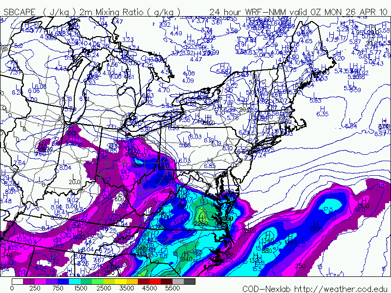

A strong jet max (area of strong winds) will move in during tomorrow afternoon and provide "lift" in the atmosphere. It will also bring in speed shear (winds increasing with height). This means that some isolated thunderstorms could develop rotating updrafts.


Tonight's batch of rain will exit the region early tomorrow morning. Widely scattered thunderstorms will then develop in the early afternoon and last into the evening. Some of these storms could quickly become severe with damaging winds and large hail. In addition, a brief tornado could also develop, however, I'm not expecting anything like what they saw in Mississippi today.

We will be tracking this through the day tomorrow and will bring you the very latest!

Friday, April 23, 2010

Strong Thunderstorms Possible Sunday

A strong upper storm system is headed east after producing tornadoes Thursday in Colorado, Kansas, and Texas. This storm may be responsible for more tornadoes Friday in the Mississippi Valley region. Virginia will begin to feel the impacts of this storm on Saturday with showers overspreading the area along with greater cloud-cover, but our risk for severe storms will arrive on Sunday.
We'll have a surge of low-level moisture from the southwest into Virginia on Sunday as the upper storm system nears. You can see the southwest surface winds into Central Virginia Sunday early afternoon, along with warm temperatures here:
And below is the resulting surge of rising dewpoint temperatures in the Commonwealth, which will approach 65 degrees Sunday afternoon:
At this time, the primary threat in Central Virginia appears to be for damaging winds, but we will be closely monitoring for the additional threat of tornadoes as well. Stay with CBS 6, we'll keep you ahead of the storm!

Thursday, April 22, 2010

Dense Fog Thursday Morning


After Wednesday's soaking rainfall in Central Virginia, winds remained light overnight with decreasing cloud-cover higher up. These factors combined have allowed widespread dense fog to develop early Thursday morning, with most visibilities at a quarter-mile or less. There is a Dense Fog Advisory in effect for most of the area until 9 a.m., but it will take most of the morning for the fog to completely lift. Fog will be at its densest in low-lying spots and also along rivers, creeks, and streams. Skies will become partly cloudy this afternoon, allowing for a warmer afternoon in the mid-70's area wide.