Friday, May 28, 2010

More Storms Possible Friday


After a round of loud, but non-severe, thunderstorms tracked through Central Virginia overnight, we could have more thunderstorms this afternoon and night in the region. The strongest storms will be capable of damaging winds and large hail. Activity will develop during the peak afternoon heating, likely along the West Virginia state line, then track east-southeast over the mountains into Central Virginia late afternoon and evening. The severe threat should rapidly diminish after sunset, and thunderstorms will die out overnight. If you have outdoor plans this evening, stay weather aware! You can point your cell phone's mobile browser to wtvr.com and keep ahead of the storm.

Thursday, May 27, 2010

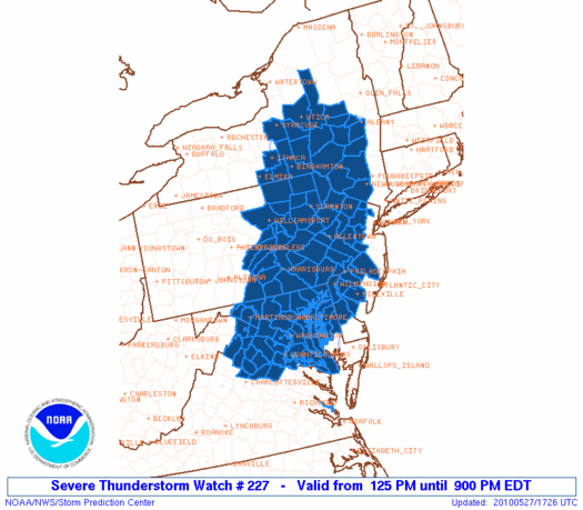
Severe Thunderstorm Watch - Thursday 5/27

A Severe Thunderstorm Watch has been issued until 9 PM for the northern third of Virginia. Upper level winds will steer storms almost straight south, so we should see thunderstorms headed into parts of central Virginia later this evening and into tonight. Large hail and strong winds will be the primary threat with these storms.


Risk for Severe Storms

Strong to severe thunderstorms may develop this afternoon to our North as a cold front makes its move south, creating a cluster of storms that may track all the way into Northern Virginia and into the Northern Neck and Middle Peninsula late this afternoon and evening. Hence, we have a slight risk for this part of the state:

We could also see isolated afternoon storms develop anywhere in Central Virginia today with peak afternoon heating and humid conditions, and those could also be quite strong. That same approaching cold front on Friday could enhance thunderstorm chances in the afternoon and evening as it tracks into Virginia. It looks like most of us will have a good chance for rain and storms Friday, and some of these storms could be severe with damaging winds and large hail:

Showers may stick around Saturday, too, with mostly cloudy skies, but by Sunday we should be dry and warmer in the 80's.