Three storm systems tracking along the northern border of the U.S. caused everything from damaging winds, to snow, and heavy rain this weekend. The first storm to mention is the same system that brought gusty winds to Virginia Sunday and scattered light rain showers continuing into Monday morning. But farther to our north, this system disrupted flights in the Northeast with gusty winds up to 74 mph. Before the front moved through Virginia, near-record highs occurred in many locations. Richmond's Sunday high was 74 degrees, just three degrees short of the record high for December 28 of 77 in 1984.
The next system on the map moved through Wyoming and Montana, with gusts up to 71 mph at Bordeaux, WY, 61 mph at Arlington, WY, and 60 mph at Miles City, MT. This small system is moving through the Dakotas Monday morning, bringing a light snowfall of a few inches.
The last storm system in the country right now is moving into the Pacific Northwest, and it has produced impressive rainfall totals so far. Here are some of the totals late Saturday into Sunday:
3.5” rain in 6 hours at Obrien, OR
3.2” rain in 9 hours at Powers, OR
2.9” rain in 12 hours at Brookings, OR
3.3” rain in 23 hours at Myrtle Point, OR
2.3” rain in 24 hours at Scottsburg, OR
This storm system will approach the East coast by New Year’s Eve, and will bring us cooler weather in time for New Year’s Day. At most, this system may squeeze out some flurries in the Virginia mountains west.
The next storm system to bring us a chance of rain will follow quickly on the heels of the previous one, bringing us a decent chance for rain and possibly a wintry mix on Friday.
--Carrie

Monday, December 29, 2008


Sunday, December 28, 2008
Patchy fog Sunday morning
(Updated Sunday afternoon)
A Dense Fog Advisory was in effect for parts of south-central and southeast Virginia Sunday morning until 8 a.m. Air temperatures and dew point temperatures were very close to each other this morning, which put relative humidity values in the 90% range. Patchy fog also occurred in the Richmond area. Winds increased in speed by mid-morning, though, which helped to mix the air near the surface and disperse the fog. Drizzle and light rain showers will continue to be possible today, but chances in Richmond are low through the afternoon.
High temperatures today will climb to the upper 60’s and low 70’s in Central Virginia before the cold front passes tonight. Average highs for late December are in the mid to upper 40’s. The record high for December 28 in Richmond is 77 from 1984, so today’s high will be on the upper end of our range of recorded temperatures in late December.
This unseasonably warm weather will end with the frontal passage, putting our temperatures back closer to average levels into New Year’s Eve.
--Carrie
A Dense Fog Advisory was in effect for parts of south-central and southeast Virginia Sunday morning until 8 a.m. Air temperatures and dew point temperatures were very close to each other this morning, which put relative humidity values in the 90% range. Patchy fog also occurred in the Richmond area. Winds increased in speed by mid-morning, though, which helped to mix the air near the surface and disperse the fog. Drizzle and light rain showers will continue to be possible today, but chances in Richmond are low through the afternoon.
High temperatures today will climb to the upper 60’s and low 70’s in Central Virginia before the cold front passes tonight. Average highs for late December are in the mid to upper 40’s. The record high for December 28 in Richmond is 77 from 1984, so today’s high will be on the upper end of our range of recorded temperatures in late December.
This unseasonably warm weather will end with the frontal passage, putting our temperatures back closer to average levels into New Year’s Eve.
--Carrie
Saturday, December 27, 2008
La Nina Coming Back? Potential Impacts Discussed.
I want to preface this blog entry with the fact that I am obsessed with long range forecasting. So many variables can impact a long range or seasonal forecast, it is truly mind-boggling at times. It's a new frontier in the world of meteorology...one that fascinates me.
Ok, now let's talk about the past. In late November and very early December, we were stuck in a "northwest flow" weather pattern. Storms moved into our area from central Canada. These "clipper" type of storms brought in cold air from the north, which is why we saw such a prolonged period of cool weather. In addition, these types of storms will bring only small amounts of rain or snow (occasionally there are exceptions).
We then saw an abrupt change in the pattern by the middle of this month and storms were moving in from the southwest - consequently named "southwest flow". This type of pattern yielded warmer and wetter than normal conditions.
Looking at the latest data, it looks like we are going to see the weather pattern switch back to what we saw in late November. Here is a map of the current jet stream pattern:

Notice the dip, or trough, in the jet over the western half of the U.S. and a bulge, or ridge, over the east coast. This is why we will see temps surge to near 70 tomorrow. We also have a chance for rain in the afternoon.
Look how the pattern changes by mid-January:

Now the trough is over the east coast...a pattern very similar to late November. If this forecast holds true, then temperatures will be at or below normal for the first half of the month (normal high is in the mid 40s). We could also see some snow return to the area...of course, it's still way to early to pinpoint when and how much.
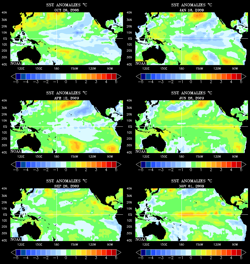
This pattern may not hold up long though. Latest data in the Pacific Ocean is indicating that La Nina may soon return. La Nina is a cold ocean current off the coast of South America. In the animation below, you can spot the La Nina from last winter (far right center of image). There was also a weak El Nino (warm current) around summertime as well.

La Nina in the wintertime will typically bring warmer than normal temperatures (depicted by the first map below) with below average precipitation (second map).


This is still very far away, but will be interesting to watch develop. I will be tracking it closely and of course have more updates later!
-Aaron-
Ok, now let's talk about the past. In late November and very early December, we were stuck in a "northwest flow" weather pattern. Storms moved into our area from central Canada. These "clipper" type of storms brought in cold air from the north, which is why we saw such a prolonged period of cool weather. In addition, these types of storms will bring only small amounts of rain or snow (occasionally there are exceptions).
We then saw an abrupt change in the pattern by the middle of this month and storms were moving in from the southwest - consequently named "southwest flow". This type of pattern yielded warmer and wetter than normal conditions.
Looking at the latest data, it looks like we are going to see the weather pattern switch back to what we saw in late November. Here is a map of the current jet stream pattern:

Notice the dip, or trough, in the jet over the western half of the U.S. and a bulge, or ridge, over the east coast. This is why we will see temps surge to near 70 tomorrow. We also have a chance for rain in the afternoon.
Look how the pattern changes by mid-January:

Now the trough is over the east coast...a pattern very similar to late November. If this forecast holds true, then temperatures will be at or below normal for the first half of the month (normal high is in the mid 40s). We could also see some snow return to the area...of course, it's still way to early to pinpoint when and how much.
This pattern may not hold up long though. Latest data in the Pacific Ocean is indicating that La Nina may soon return. La Nina is a cold ocean current off the coast of South America. In the animation below, you can spot the La Nina from last winter (far right center of image). There was also a weak El Nino (warm current) around summertime as well.
La Nina in the wintertime will typically bring warmer than normal temperatures (depicted by the first map below) with below average precipitation (second map).


This is still very far away, but will be interesting to watch develop. I will be tracking it closely and of course have more updates later!
-Aaron-
Subscribe to:
Posts (Atom)