Now that the sun is down, winds have become less gusty. This trend will continue into tonight...midnight winds will be 10 to 15 mph, then 5 to 10 mph by tomorrow morning. Highest gust in Richmond was 44 mph recorded earlier this afternoon!
Most of the flurries have also exited the area and we will have mainly clear skies for the rest of tonight.

Wednesday, December 31, 2008
Isolated Snow Showers In The Area
A few pockets of flurries have been popping up across the area. Temperatures are well above freezing, so this is all melting on impact. The chance for flurries will quickly diminish after sunset.
Here is some video of some snow captured on cell phone by Jamie Buckmaster in Chesterfield. Thanks for sending it in!
Here is some video of some snow captured on cell phone by Jamie Buckmaster in Chesterfield. Thanks for sending it in!
Damaging Winds Possible Today
(Updated Wednesday, December 31, 2008 at 10:32 a.m.)
A Wind Advisory is in effect until 10 p.m. Wednesday for all of Central Virginia. Winds will continue to increase in speed late Wednesday morning, with gusts up to 50+ at times through the day. Sustained winds will be from the West to Northwest at 30 to 40 mph. These winds will be strong enough to cause some power outages and make driving difficult at times. Secure any loose or lightweight items outdoors, including garbage cans, remaining Christmas decorations, and patio furniture. Stay with CBS 6, we'll keep you ahead of the storm.
A list of counties affected can be found here: http://www.wtvr.com/global/weatheralerts.asp?CountyID=cid2949321
--Carrie
In other weather news...

If you can brave the blustery winds this evening, step outside and look Southwest at sunset for the waxing crescent Moon and the planet Venus, which will appear as a bright dot just below the Moon. The map to the left shows what other stellar objects will be in your view (image SpaceWeather.com).
Bundle up if you are heading outside to check out the Moon and Venus, or to watch the ball rise in Carytown tonight. Temperatures will be in the 20's at Midnight. Happy New Year!
--Carrie
Tuesday, December 30, 2008
Bugs and Meteors
The following is an e-mail from a viewer with my response:
Hello,
My name is Martha and about 5:40 p.m. today, December 21, I went outside and something caught my eye in the sky. I quickly looked up and there was a small ball of fire in the northern sky which raced across for about 2 seconds and then disintegrated. I have seen shooting stars and this was nothing like it. It was actually on fire. I live in Ophelia, about 6 miles from Reedville, where the Potomac and the Chesapeake Bay meet. Could you tell me, if you know, what that could have possibly been? Thank you.
Martha A.
Ophelia, Va
Hi Martha! What you saw is most likely what is called an “earthgrazer”. It’s basically a meteor that just skims the earth’s atmosphere and causes a long, brilliant trail across the sky. Sometimes the smoke trail will last a few seconds after the meteor has passed. The earthgrazer meteors (shooting stars) occur early in the evening when our direction as we travel through space is sideways.
Think of it this way: A meteor is caused by intense frictional heating of the atmosphere as debris enters at a high rate of speed and burns up. The earth is flying through space, and our atmosphere is encountering debris all the time. Pretend for a moment that the earth is a car and the sky overhead is a windshield. When the sun sets, we are looking out the side window of the car, with the front windshield to the east. As the night wears on, the earth rotates in such a way that the front windshield is overhead around dawn. Now pretend the debris that enters the atmosphere are bugs hitting the imaginary windshield. If we are looking out the side window at sunset, as you were when you saw the earthgrazer, the bug would have just barely skimmed the glass and made a long streak down the window. If you had seen the same bug strike the windshield around sunrise the next morning, the streak would have been brighter but much shorter, as you would have been looking out the front window of our imaginary car. Hope this analogy helps, and I’m glad you got to see an earthgrazer!

Zach
Monday, December 29, 2008
Weekend Weather Wrap-up
Three storm systems tracking along the northern border of the U.S. caused everything from damaging winds, to snow, and heavy rain this weekend. The first storm to mention is the same system that brought gusty winds to Virginia Sunday and scattered light rain showers continuing into Monday morning. But farther to our north, this system disrupted flights in the Northeast with gusty winds up to 74 mph. Before the front moved through Virginia, near-record highs occurred in many locations. Richmond's Sunday high was 74 degrees, just three degrees short of the record high for December 28 of 77 in 1984.
The next system on the map moved through Wyoming and Montana, with gusts up to 71 mph at Bordeaux, WY, 61 mph at Arlington, WY, and 60 mph at Miles City, MT. This small system is moving through the Dakotas Monday morning, bringing a light snowfall of a few inches.
The last storm system in the country right now is moving into the Pacific Northwest, and it has produced impressive rainfall totals so far. Here are some of the totals late Saturday into Sunday:
3.5” rain in 6 hours at Obrien, OR
3.2” rain in 9 hours at Powers, OR
2.9” rain in 12 hours at Brookings, OR
3.3” rain in 23 hours at Myrtle Point, OR
2.3” rain in 24 hours at Scottsburg, OR
This storm system will approach the East coast by New Year’s Eve, and will bring us cooler weather in time for New Year’s Day. At most, this system may squeeze out some flurries in the Virginia mountains west.
The next storm system to bring us a chance of rain will follow quickly on the heels of the previous one, bringing us a decent chance for rain and possibly a wintry mix on Friday.
--Carrie
Sunday, December 28, 2008
Patchy fog Sunday morning
(Updated Sunday afternoon)
A Dense Fog Advisory was in effect for parts of south-central and southeast Virginia Sunday morning until 8 a.m. Air temperatures and dew point temperatures were very close to each other this morning, which put relative humidity values in the 90% range. Patchy fog also occurred in the Richmond area. Winds increased in speed by mid-morning, though, which helped to mix the air near the surface and disperse the fog. Drizzle and light rain showers will continue to be possible today, but chances in Richmond are low through the afternoon.
High temperatures today will climb to the upper 60’s and low 70’s in Central Virginia before the cold front passes tonight. Average highs for late December are in the mid to upper 40’s. The record high for December 28 in Richmond is 77 from 1984, so today’s high will be on the upper end of our range of recorded temperatures in late December.
This unseasonably warm weather will end with the frontal passage, putting our temperatures back closer to average levels into New Year’s Eve.
--Carrie
Saturday, December 27, 2008
La Nina Coming Back? Potential Impacts Discussed.
I want to preface this blog entry with the fact that I am obsessed with long range forecasting. So many variables can impact a long range or seasonal forecast, it is truly mind-boggling at times. It's a new frontier in the world of meteorology...one that fascinates me.
Ok, now let's talk about the past. In late November and very early December, we were stuck in a "northwest flow" weather pattern. Storms moved into our area from central Canada. These "clipper" type of storms brought in cold air from the north, which is why we saw such a prolonged period of cool weather. In addition, these types of storms will bring only small amounts of rain or snow (occasionally there are exceptions).
We then saw an abrupt change in the pattern by the middle of this month and storms were moving in from the southwest - consequently named "southwest flow". This type of pattern yielded warmer and wetter than normal conditions.
Looking at the latest data, it looks like we are going to see the weather pattern switch back to what we saw in late November. Here is a map of the current jet stream pattern:

Notice the dip, or trough, in the jet over the western half of the U.S. and a bulge, or ridge, over the east coast. This is why we will see temps surge to near 70 tomorrow. We also have a chance for rain in the afternoon.
Look how the pattern changes by mid-January:

Now the trough is over the east coast...a pattern very similar to late November. If this forecast holds true, then temperatures will be at or below normal for the first half of the month (normal high is in the mid 40s). We could also see some snow return to the area...of course, it's still way to early to pinpoint when and how much.
This pattern may not hold up long though. Latest data in the Pacific Ocean is indicating that La Nina may soon return. La Nina is a cold ocean current off the coast of South America. In the animation below, you can spot the La Nina from last winter (far right center of image). There was also a weak El Nino (warm current) around summertime as well.
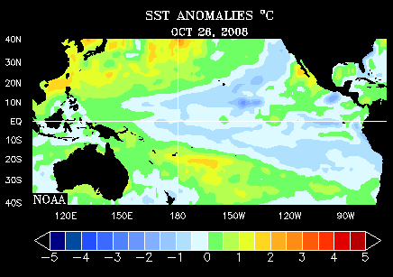
La Nina in the wintertime will typically bring warmer than normal temperatures (depicted by the first map below) with below average precipitation (second map).


This is still very far away, but will be interesting to watch develop. I will be tracking it closely and of course have more updates later!
-Aaron-
Ok, now let's talk about the past. In late November and very early December, we were stuck in a "northwest flow" weather pattern. Storms moved into our area from central Canada. These "clipper" type of storms brought in cold air from the north, which is why we saw such a prolonged period of cool weather. In addition, these types of storms will bring only small amounts of rain or snow (occasionally there are exceptions).
We then saw an abrupt change in the pattern by the middle of this month and storms were moving in from the southwest - consequently named "southwest flow". This type of pattern yielded warmer and wetter than normal conditions.
Looking at the latest data, it looks like we are going to see the weather pattern switch back to what we saw in late November. Here is a map of the current jet stream pattern:

Notice the dip, or trough, in the jet over the western half of the U.S. and a bulge, or ridge, over the east coast. This is why we will see temps surge to near 70 tomorrow. We also have a chance for rain in the afternoon.
Look how the pattern changes by mid-January:

Now the trough is over the east coast...a pattern very similar to late November. If this forecast holds true, then temperatures will be at or below normal for the first half of the month (normal high is in the mid 40s). We could also see some snow return to the area...of course, it's still way to early to pinpoint when and how much.
This pattern may not hold up long though. Latest data in the Pacific Ocean is indicating that La Nina may soon return. La Nina is a cold ocean current off the coast of South America. In the animation below, you can spot the La Nina from last winter (far right center of image). There was also a weak El Nino (warm current) around summertime as well.
La Nina in the wintertime will typically bring warmer than normal temperatures (depicted by the first map below) with below average precipitation (second map).


This is still very far away, but will be interesting to watch develop. I will be tracking it closely and of course have more updates later!
-Aaron-
Friday, December 26, 2008
Rain Friday afternoon with more possible this weekend
Rain moving through Central Virginia Friday afternoon will taper off through the early evening hours, and be gone by midnight. Skies will remain mostly cloudy overnight, though, and temperatures will hold nearly steady in the low 40’s all night. Winds will remain from the south through the next 24 hours, and that will assist in ushering warmer air back into the state for Saturday, when highs should rebound into the upper 50’s and 60’s. There will be a slight chance for isolated showers in the state Saturday and again Sunday morning, but the highest chances will come with the next storm system expected to move through Sunday night.
This approaching storm system is the same one that brought record-setting snow to the Western U.S. on Christmas Day. Lake Tahoe, California had two feet of snow on Christmas, putting their two-week snow total at 10 feet. In fact, even Las Vegas, Nevada had a “White Christmas” with snowfall around 10 p.m. local time on December 25. This makes only three years on record for a Vegas Christmas snowfall: 2008, 1988, and 1941. This is also the fourth calendar day in December with snow recorded in Las Vegas, tying December 1967 for the most December snow days.
--Carrie
Isolated Showers Possible
Temperatures have luckily warmed up into the upper 30s and lower 40s across the entire area, so roads should be fine for the rest of today and tonight. Isolated showers will be possible, but today won't be a complete washout if you plan on being outside shopping today.
Light Rain Developing To The South
Light rain is now moving through Charlotte and Lunenburg counties. This batch of rain is moving to the east and will affect Dinwiddie, Brunswick, and Greensville counties. Temperatures are still hovering around the freezing mark, so some slick spots could develop, especially on bridges and overpasses. I just checked road conditions across the state, and luckily there are currently no hazards. I will have another update in the next hour.
Thursday, December 25, 2008
Holiday Temperature Roller Coaster
Christmas week has been a bit of a temperature roller coaster for Central Virginia as the active weather pattern in the U.S. continues to bring systems through the region in rapid succession. Here is the temperature summary for this week in Richmond:
Sunday, December 21: Low 33, High 49, 0.36” Rain.
Monday, December 22: Low 21, High 32.
Tuesday, December 23: Low 17, High 37.
Wednesday, December 24: Low 35, High 65, 0.02” Rain.
Thursday, December 25: Low 50, High 63.
Christmas Day in Central Virginia turned out to be a sunny, gorgeous day with clear-blue skies and rain moving out of the area well before sunrise. The high temperature of 63 degrees today actually occurred around midnight, but after falling to 50 degrees at sunrise, afternoon temperatures were able to climb back up to 60 degrees in the sunshine. I expect a new low temperature will be set for today just before midnight. High pressure will settle over Virginia with mostly clear skies overnight into Friday morning, which will make for a colder Friday morning around freezing.
The temperature roller coaster will continue Saturday, when a warm front will lift back North into the state, upping highs back to the 60s. Another round of rain is also likely as the next storm system approaches Sunday.
In one week, Richmond will have seen a temperature spread of 49 degrees, from 17 degrees Tuesday all the way up to a forecast 66 degrees Saturday.
--Carrie
Wednesday, December 24, 2008
Winter Weather Mess Well North of Virginia
Southerly winds returned Tuesday, ushering warmer air back into Central Virginia before a storm system began tracking through the East. This storm system is yet another in a series of record-setting winter weather storms to move through the Midwest and Northeast in the past couple of weeks. Early Wednesday morning, freezing rain and a wintry mix were affecting the Northeast U.S., with rain showers moving through Central Virginia. It was the southerly wind that ushered in warmer temperatures and protected Central Virginia from a freezing rain threat Wednesday morning. Rain chances will increase overnight into early Christmas Morning as the cold front moves through Virginia, but most of the rain will move southeast by late Christmas Morning.
With the rain and winter weather in the Northeast, and also on the West Coast, you may need to check travel information if you plan to fly the next several days. You can get updates on airport delays at this link: http://www.fly.faa.gov/flyfaa/plaintext.html
--Carrie
With the rain and winter weather in the Northeast, and also on the West Coast, you may need to check travel information if you plan to fly the next several days. You can get updates on airport delays at this link: http://www.fly.faa.gov/flyfaa/plaintext.html
--Carrie
Tuesday, December 23, 2008
Winter Weather Advisory North & West
A Winter Weather Advisory has been issued for areas near and west of Charlottesville and all along I-81. This also includes Buckingham and Appomatox counties in central VA and is in effect until 4 AM.

Temperatures continue to hover around freezing across the state. In addition, isolated light showers or even sprinkles have developed. Once on the ground, the rain could freeze and cause some slick spots on roads this evening and into early tonight - especially on bridges and overpasses. Here is a map to track temperatures (it will continually update through the night).

There is also a Winter Weather Advisory from Fredericksburg northward into D.C. and is in effect until 10 AM for the same reasons stated above. Use extreme caution if traveling north on I-95 this evening and tonight!
Luckily I'm expecting temperatures to hold steady for the next couple hours in central Virginia. Temps will then begin to rise after midnight, so that the threat for slick spots will quickly diminish.

Temperatures continue to hover around freezing across the state. In addition, isolated light showers or even sprinkles have developed. Once on the ground, the rain could freeze and cause some slick spots on roads this evening and into early tonight - especially on bridges and overpasses. Here is a map to track temperatures (it will continually update through the night).
There is also a Winter Weather Advisory from Fredericksburg northward into D.C. and is in effect until 10 AM for the same reasons stated above. Use extreme caution if traveling north on I-95 this evening and tonight!
Luckily I'm expecting temperatures to hold steady for the next couple hours in central Virginia. Temps will then begin to rise after midnight, so that the threat for slick spots will quickly diminish.
The Ghosts of Christmas Past and Christmas Yet to Come
Most of Central Virginia bottomed out in the teens Tuesday morning, thanks to clear skies, cold and dry Arctic air, and calm winds overnight. However, this cold will not linger past Tuesday. High pressure currently over the East-central coast will move out to sea, allowing our winds to return to the South by Tuesday afternoon. This will usher in warmer air from the south at the same time as an approaching low pressure system tracks north of Virginia.
This storm system is yet another in a series of record-setting winter weather storms to move through the Midwest and Northeast in the past couple of weeks. But Central Virginia will escape yet again the snow associated with this system. This does beg the question, though, of when was the last time Richmond had a White Christmas?
Well, that all depends on your definition of a “White Christmas!” If you are satisfied with merely getting snow flurries and a light dusting on Christmas Day, then the last time that happened in Richmond was in 1993. Light snow showers started around mid-day and continued through the afternoon, accumulating about a tenth of an inch of snow. The last time before 1993 there was a light snowfall was 1985.
But, if you want a more “legitimate” White Christmas, the last time at least one inch of snow fell on Christmas Day in Richmond was in 1981, later in the day. The last time kids could wake up to an inch of snow on the ground Christmas Morning was 1966.
It has been a hundred years since the greatest Christmas Morning snow depth in Richmond. Seven inches of snow blanketed Richmond Christmas Morning in 1908. Several years later in 1914, it snowed 5.4 inches in Richmond on Christmas Day.
Snow aside, the coldest Christmas Day was in 1983, when the high temperature in Richmond was only 14 degrees, with a low of just three degrees.
We do remain in a very active weather pattern, however, and our next storm system will track just to our north Christmas Eve and Day, bringing a decent chance for rain Wednesday and Thursday. Richmond will be too warm for snowfall, but there may be some flurries in the western parts of the state, especially in the mountains, before this system moves out.
--Carrie
Monday, December 22, 2008
Arctic air settling in over Virginia
The latest in a series of storm systems tracking through the Midwest and Northeast has brought cold, Arctic air to Central Virginia Monday. The front that moved through Sunday has made it to southern Florida Monday morning. Cold, high pressure is settling in over the Eastern U.S. Monday in the wake of the low pressure system exiting north of Maine.
This air now in place is dry and Arctic in origin, passing over plenty of snowpack to Virginia’s northwest. This means that the air does not modify too much on its way south toward Central Virginia. Low temperatures Monday morning were in the teens and low twenties, with a brisk Northwest wind at 10-20 mph making it feel like it was only in the single digits and teens.
But as cold as it felt here Monday morning, we escaped the worst of this last system. Portland, Maine set a new daily snowfall record for December 21 with 14.5” of snow. This broke a 75-year-old record by more than two inches. Albany, New York broke an even longer-standing record, though, with 6.6” of snow December 21 surpassing the old record of 5.7” set back in 1887. In addition to the snow from this storm system, wind chills were also brutally cold by Monday morning. It felt like -20 to -30 degrees from Iowa to Wisconsin and Minnesota, and North into the Dakotas.
As the high pressure parks over Virginia Monday evening, winds will weaken. Combine calm winds with clear skies and cold, dry air, and we have a perfect recipe for an even colder Tuesday morning in Central Virginia. I expect morning lows to bottom out in the teens in most places.
Southerly winds will return, though, after Tuesday morning, which will begin a gradual warming trend through the rest of this week. We do remain in a very active weather pattern, however, and our next storm system will track just to our north by Christmas Eve and Day, bringing a decent chance for rain Wednesday and Thursday.
Sunday, December 21, 2008
Recap Of Autumn 2008
This autumn has been interesting to say the least. It started off with a bang when we saw over 2" of rain from Sept 25-26. Things quickly became stagnant in October, where we saw below average rainfall and temperatures that were just a hair above normal.
Significant changes arrived by November, especially late in the month. This quick change in weather pattern snapped our dry spell - rain totals ended up above average. Although the end of the month was extremely chilly, the average temp for the whole month was only barely below normal.
We then saw a complete change in the weather pattern heading into December. This month has been exceptionally wet and mild.
It's important to look back on the weather pattern during the fall because this can carry over into winter. More than likely we will see an abrupt change in the pattern next month, which means temps will drop back below normal for an extended period of time...just like in late November. During this transition, we could finally see our first real snowfall of the season!
Rainy Sunday morning, but clearing in afternoon
A strong low pressure storm system is moving through the Northeast Sunday morning, bringing rain to much of Virginia. Early Sunday morning, a winter mix of precipitation was occurring in the mountains out west, and also in north-central Virginia from Fredericksburg to D.C. For this reason, there is a Winter Weather Advisory in effect until 10 a.m. for those counties out west and far north-central. This storm system will quickly move northeast Sunday afternoon, ending central Virginia's rain chances by early afternoon. On the backside of this low, much colder air will settle in over the region, with low temperatures falling into the 20's Monday morning in central Virginia, and into the teens by Tuesday morning. Another round of rain is expected by Christmas Eve and lasting into Christmas Day. At this time, it looks like this system will bring rain to central Virginia instead of a White Christmas.
-Carrie
-Carrie
Saturday, December 20, 2008
Winter Weather Advisory To The West
A Winter Weather Advisory has been issued for communities to the west. Here is a map of the counties affected:

Although most of central Virginia is not in this advisory, we could still see a few ice pellets mixed in with the rain tonight and very early tomorrow morning. Temperatures will be in the upper 30s during this time, so these pellets will quickly melt on impact.
This is a situation that we are watching very closely and we will continue to bring you the very latest as this storm passes the area.
Friday, December 19, 2008
Much Colder Air Arrives Saturday
A cold front will move through central Virginia overnight, clearing the state by midday Saturday. Temperatures will slowly fall from the upper 40s at sunrise, to the low 40s at sunset. A storm system will bring rain to the area Saturday night through Sunday, with a winter mix expected north and west of Richmond.
Zach
Zach
Fog Expected To Lift Soon
The fog is sluggish to exit the region. Visibilities all along I-95 are still below one mile. Here are some images from our Sky Tracker cameras. The first one is our camera on the Dominion building...you can't see anything because of the fog!

Things are looking gray on Broad Street in the Near West End.

There has been some improvement in Petersburg, but outlying areas are still foggy.


Things are looking gray on Broad Street in the Near West End.

There has been some improvement in Petersburg, but outlying areas are still foggy.

The airport is still looking bad.


Things are looking a lot better to the southwest, where in Danville and South Hill, visibilities have increased above three miles. This trend will continue farther north into central Virginia in the next couple hours and we will be done with the fog by this evening.
Although most of the rain has moved north, we could still see a stray shower this afternoon and early evening.
Although most of the rain has moved north, we could still see a stray shower this afternoon and early evening.
Fog Continues
Visibilities are still below a mile for most of central Virginia. In fact, visibilities are less than a quarter mile in Charlottesville, Farmville and South Hill!
Here is what it looks like in downtown Richmond. We are looking off to the west - the downtown expressway is at the bottom of the image.

Here is a view from the ground from our rooftop camera here at the studios in the West End on Broad Street.

I'm still expecting visibilities to improve around noon today. However, spotty showers will still be possible into the afternoon.
Dense Fog This Morning
Areas along and west of I-95 are experiencing dense fog this morning. For this reason, Greensville County Schools are on a two hour delay and Brunswick County Schools are on a one hour delay.
Visibilities are below one mile in most locations, so this could slow you down for your morning commute. Most of the fog will lift and visibilities will improve by noon.
Isolated light showers are also moving across the area this morning. We will have a chance for hit-and-miss showers into the afternoon and then dry off later this evening.
Thursday, December 18, 2008
Dense Fog Likely Again Overnight
Areas of dense fog will develop tonight across much of southern and southwestern Virginia, including the counties of Buckingham, Appomattox, and Charlotte. Southwest winds will develop by mid-morning Friday, clearing the fog in most areas.
Zach
Zach
Fog Slowly Lifting Out West
Conditions are improving for communities out west, where some patches of dense fog had developed earlier this morning. Visibilities in Danville are now at 2 miles, however, visibilities in Lynchburg are still below a mile. This fog will briefly lift in the afternoon and then redevelop later tonight.
Wednesday, December 17, 2008
Patchy Fog Possible Overnight
A cold front will continue to slowly move through the area tonight. Relatively high low-level moisture combined with falling temperatures will yield relative humidity values in the 90-100% range for much of the night. Patchy dense fog will likely develop, reducing visibilities significantly in localized areas.
Zach
Zach
Tuesday, December 16, 2008
Cold and Wet Overnight
Occasional light rain, fog, and drizzle will continue overnight in central Virginia. Temperatures will remain in the upper 30s in all areas except the far western and northern counties of the state, where a winter weather advisory remains in effect through early Wednesday. A light coating of ice, mixed with light sleet, will continue to be possible in these areas through the period.
Zach
Zach
Big Changes Today!
Spotty showers and embedded downpours have been moving across the area this morning and should persist into the afternoon and evening. Just three hours ago, temperatures were in the low 60s. Once the front passed, temps quickly dropped into the 40s - almost thirty degrees cooler than yesterday afternoon!
Monday, December 15, 2008
Record High Tied Monday in Richmond
The high temperature in Richmond reached 73 on Monday, tying the record set in 1984. A cold front will move through Richmond at 3 AM Tuesday, ushering in a much colder air mass, and ending our short-lived warm up. Afternoon temperatures on Tuesday will be 25-30 degrees colder than those at the same time Monday. A winter storm watch is in effect for northwest Virginia, Tuesday night into Wednesday morning.
Zach
Zach
Isolated Showers Today
A few showers developed earlier this morning mainly west of I-95 and north of I-64. These have diminished, but isolated showers are still possible for the rest of today.
Check out how cold it is out west - temps were well below zero in the upper Midwest for this morning!

This region dealt with a major storm over the weekend that dumped over a foot of snow in some locations (indicated by the deep shades of blue).

Check out how cold it is out west - temps were well below zero in the upper Midwest for this morning!

This region dealt with a major storm over the weekend that dumped over a foot of snow in some locations (indicated by the deep shades of blue).

Friday, December 12, 2008
Check Out the "Perigee" Full Moon Tonight
The moon's orbit around the earth is not a perfect circle. At it's farthest point from earth, it's called at apogee, and it's at perigee at the closest point. Tonight's full moon is closest to perigee, and appears 14% larger and 30% brighter than full moons at apogee. Grab a jacket and go check it out. It's most dramatic when it's closer to the horizon. Have a great weekend!

Zach
Update On Streams & Rivers
After yesterday's rain storm, rivers and streams are now all running at average or above average levels (indicated by the blue and black dots). It's hard to believe that almost all of these were running below normal just a couple days ago!
There are some minor flooding concerns at the Dan River in Halifax County and at the Meherrin River in Brunswick County. River levels will drop substantially by tomorrow morning for both counties.

There are some minor flooding concerns at the Dan River in Halifax County and at the Meherrin River in Brunswick County. River levels will drop substantially by tomorrow morning for both counties.

Rain Is Now Gone
The rain has finally exited the area this morning - there were even a few peeks of sunshine! We will see a few clouds lingering into the afternoon and possibly a stray sprinkle, otherwise skies will clear out into tonight.
Thursday, December 11, 2008
Two New Records at RIC
The massive storm system responsible for 25 tornadoes and snow in states that rarely ever see it, left it's mark in the Richmond record book. The warm air mass that streamed into the area yesterday ahead of the system resulted in an all-time record warm low temperature in Richmond for December 10th. The low never dropped below 61 degrees, breaking the old record of 60. The total rainfall for today has yet to be established, but as of 7 PM, a total of 1.90 inches had fallen, breaking the old record of 1.85 inches set back in 1960. Moderate to occasionally heavy rainfall will continue in central Virginia through 10 PM. The flood watch will continue until midnight tonight, as runoff will continue to cause flooding problems.
Zach
Zach
Tornado Watch in Effect Until 9 PM
A tornado watch has been issued for southeast Virginia, including Brunswick, Greensville, Surry, and Sussex counties until 9 PM.
Zach
Zach
Rain Totals Keep Climbing
Highest rain totals so far have been in western Amelia County and Prince Edward County, where almost an inch of rain has already fallen. Isolated thunderstorms have also popped up near Virginia Beach. The best chances for thunderstorms will continue to be in the southeast corner of the state.
Here is a map of real-time stream flow across the state. The orange and red dots represent streams/rivers with below normal flow. Green or blue dots show streams/rivers that are average or above average.

Right now the streams are running very low because of a recent dry spell. Rain totals from this storm should range from 1 to 3", so this will definitely change later tonight!
Here is a map of real-time stream flow across the state. The orange and red dots represent streams/rivers with below normal flow. Green or blue dots show streams/rivers that are average or above average.
Right now the streams are running very low because of a recent dry spell. Rain totals from this storm should range from 1 to 3", so this will definitely change later tonight!
Steady Rain This Morning
A slow soaking rain is moving across the area for this morning. Rain totals have ranged from a quarter to a half inch so far with more on the way. The core of the storm system is spinning over New Orleans, so this is just one of many rounds of rain that will move across the area.
Wednesday, December 10, 2008
Flood Watch in Effect for Central Virginia
A flood watch is in effect Wednesday night through Thursday, as most of central Virginia is expected to receive periods of very heavy rain through the period. Most locations will pick up at least an inch of rain, with the greatest potential for more than 3 inches of rain southeast of the Richmond Metro Area. Light rain will increase in coverage through midnight tonight, with heavier rain and a few thunderstorms moving in between midnight and dawn.
Zach
Zach
Impressive Rain Potential
A stray shower will be possible this morning and early afternoon with a better chance for rain this evening and tonight. This storm system is tapping into a lot of moisture, which means that we could see a good soaking! Latest data shows anywhere from 1 to 3" of rain falling across the area. Here is a map of forecasted rain totals for the entire east coast. The deep purples indicate 1 to 2" while the reds represent totals exceeding 3".

These totals will depend heavily on if your neighborhood sees a thunderstorm or not. Regardless, some much-needed rainfall is headed this way!

These totals will depend heavily on if your neighborhood sees a thunderstorm or not. Regardless, some much-needed rainfall is headed this way!
Tuesday, December 9, 2008
Storm Update
A broad storm system will continue to affect our weather through the end of the work week. Widespread heavy rain is expected, with in excess of 2" of rain possible in central Virginia. The threat for strong to severe thunderstorms will bear close watching as well. As the system exits the area, enough cold air should be present for a light wintery mix early Friday.
Zach
Zach
Chance For Ice Diminishes
Temperatures continue to climb into the mid 30s and lower 40s across the entire area. Spotty light showers have developed in the southwest corner of the state and should slowly move into our skies later today. We will finish today with patches of light rain or drizzle and mild temperatures. In fact, temperatures will not drop off after sunset, instead they will hold steady or even rise!
Quiet For Now
Right now we have mostly cloudy skies and dry conditions. Temperatures across central Virginia are mainly in the mid 30s. Temps farther west in Charlottesville, Farmville and Lynchburg are hovering around the freezing mark. I've noticed a spot of moisture pop up in northern Buckingham county. More than likely that moisture is evaporating before it hits the ground.
I'm expecting isolated patches of drizzle will develop west of I-95 by late this morning. With temps near the freezing mark, some ice could develop. I will continue to monitor the situation and more updates through the morning.
Aaron
ajustus@wtvr.com
I'm expecting isolated patches of drizzle will develop west of I-95 by late this morning. With temps near the freezing mark, some ice could develop. I will continue to monitor the situation and more updates through the morning.
Aaron
ajustus@wtvr.com
Monday, December 8, 2008
Light Freezing Rain/Drizzle/Fog Possible Tuesday AM
Very dry air is in place across central Virginia, and temperatures are falling close to or just below freezing in many areas. A favorable pattern for light precipitation will develop overnight, possibly resulting in a brief window of icy weather. Fog, drizzle, or sprinkles could develop in an air mass that is near or below freezing for a few hours early Tuesday. The concern would be limited to bridges and overpasses, where a thin layer of ice will be possible.
Zach
Zach
Sunday, December 7, 2008
Cold Start to the Work Week
Monday will be a cold day in central Virginia, with temperatures only reaching the low 40s. I expect a big warm up on Tuesday and Wednesday, with highs in the upper 50s and low 60s. Rain will become likely by mid week with the approach of a strong storm system. Have a great work week!
Zach
Zach
Flurries Exit, Winds Strengthen
Flurries continue to diminish across the area this morning and we will finish the day with partly cloudy skies and dry conditions. At this hour we have winds from the west at 5 to 15 mph. They will strengthen to 20 to 25 mph in the afternoon with gusts up to 35 mph. The wind will then drop to 5 to 15 mph after sunset.
Flurries Linger This Morning
Doppler Max 6 has detected a few flurries north of I-64 in Albemarle, Louisa, Spotsylvania and Caroline counties. These are drifting to the southeast and could clip the Richmond metro area and possibly farther south into Petersburg. A few flakes will be possible for the next couple hours, then we will have partly cloudy skies for the rest of the today.
Winds will strengthen into the afternoon with gusts up to 35 mph from the northwest. Winds will quickly diminish after sunset.
Winds will strengthen into the afternoon with gusts up to 35 mph from the northwest. Winds will quickly diminish after sunset.
Saturday, December 6, 2008
Snow Will Exit Tonight
Light snow continues to drift to the east and will eventually taper to flurries tonight. Temperatures remain well above freezing in and around Richmond, so most of the snow is melting on impact. Still use caution when driving tonight especially on bridges and overpasses, where a few slick spots could develop.
Tuesday, December 2, 2008
Wrap Up Of 2008 Hurricane Season
November 30th marked the official end to hurricane season. Although tropical systems can still develop in December, the chances are extremely slim. On the graph below, you can see how quickly the number of storms drop off through the month of November.

2008 will go down as an active hurricane season. There were fifteen named storms - seven of them becoming hurricanes. Here is a break-down of each storm.
8 Tropical Storms:
Arthur, Cristobal, Edouard, Fay, Josephine, Laura, Marco, Nana
4 Hurricanes:
Dolly, Hanna, Kyle, Omar
3 Major Hurricanes:
Bertha, Gustav, Ike
We experienced the remnants of both Fay and Hanna here in central Virginia (Cristobal was a near miss). Luckily neither storm created widespread damage. Instead, they brought some much needed rain to our drought-stricken area.
Here is a plot of all the storm tracks this season.

Monday, December 1, 2008
Gradual Clearing Expected Tonight
Skies will gradually clear tonight as drier and colder air moves into the area. Wind speeds will decrease as well, allowing overnight lows to fall into the low to mid 30s.
Zach
Zach
Isolated Showers This Afternoon
Spotty showers have developed this afternoon and will be possible into early this evening. In addition, winds will remain gusty through at least 11 PM before diminishing later tonight. Quiet weather will then return for Tuesday.
Sunny For Some
We finally got to see the sunshine this morning! A quick look at our Skytracker camera at Million Air at RIC shows clear skies.


However, clouds linger for some areas. Check out one of our cameras in Hanover County at Randolph Macon College.

We will see periods of clouds for the rest of today with a very slim chance for a passing shower in the afternoon. Winds will remain gusty through the evening and then diminish later tonight.

We will see periods of clouds for the rest of today with a very slim chance for a passing shower in the afternoon. Winds will remain gusty through the evening and then diminish later tonight.
Subscribe to:
Posts (Atom)