
Ok, now let's talk about the past. In late November and very early December, we were stuck in a "northwest flow" weather pattern. Storms moved into our area from central Canada. These "clipper" type of storms brought in cold air from the north, which is why we saw such a prolonged period of cool weather. In addition, these types of storms will bring only small amounts of rain or snow (occasionally there are exceptions).
We then saw an abrupt change in the pattern by the middle of this month and storms were moving in from the southwest - consequently named "southwest flow". This type of pattern yielded warmer and wetter than normal conditions.
Looking at the latest data, it looks like we are going to see the weather pattern switch back to what we saw in late November. Here is a map of the current jet stream pattern:

Notice the dip, or trough, in the jet over the western half of the U.S. and a bulge, or ridge, over the east coast. This is why we will see temps surge to near 70 tomorrow. We also have a chance for rain in the afternoon.
Look how the pattern changes by mid-January:

Now the trough is over the east coast...a pattern very similar to late November. If this forecast holds true, then temperatures will be at or below normal for the first half of the month (normal high is in the mid 40s). We could also see some snow return to the area...of course, it's still way to early to pinpoint when and how much.
This pattern may not hold up long though. Latest data in the Pacific Ocean is indicating that La Nina may soon return. La Nina is a cold ocean current off the coast of South America. In the animation below, you can spot the La Nina from last winter (far right center of image). There was also a weak El Nino (warm current) around summertime as well.
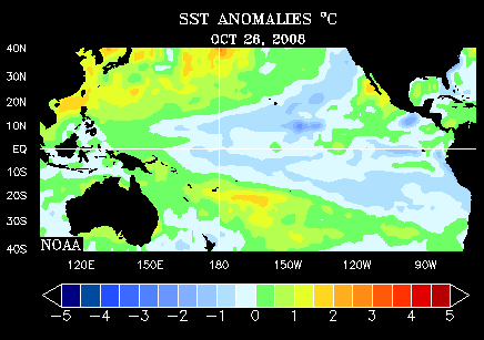
La Nina in the wintertime will typically bring warmer than normal temperatures (depicted by the first map below) with below average precipitation (second map).


This is still very far away, but will be interesting to watch develop. I will be tracking it closely and of course have more updates later!
-Aaron-